Main Menu
The main menu is available from both the Main Screen and the MyTracks Screen. It extends the menu of the original MyTracks App which has the following items:
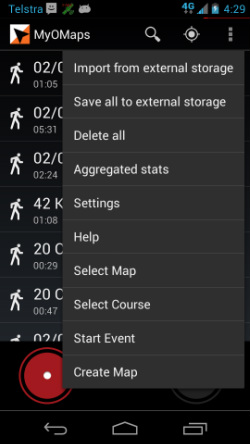
- Import from external storage – to retrieve stored tracks from the SD card
- Save all to external – saves all tracks to the SD card
- Delete all – deletes all tracks
- Aggregrated stats – gives the summation of all recorded tracks
- Settings – changes a wide range of settings. This has been extended to add orienteering- specific settings (See the section below)
- Help – provides general MyOMaps help
Note: Not all menu items are available in the iOS version.
The extended menu includes the following specific functions:
- Select Map – gives direct access to the function to import Orienteering Maps (as otherwise accessed from the "Select Map' button on the MyOMaps Main Screen)
- Select Course - gives direct access to the function to import IOF XML Course files (as otherwise accessed from the "Select Course" on the MyOMaps Main Screen). The valid file formats are: IOF XML v2.0.3 and XML created by GoogleMaps.
- Start Event – goes to the event screen otherwise accessed form the “Start Event” button on the main screen (This uses a "scatter" course type. To access other types, use the Main screen)
- Create Map – This provides access to the functionality to created a geo-referenced map from an image file (either a local image most likely from the camera) or from the Google Drive.
