OCAD - Maps and Courses
MyOMaps needs a geo-referenced map file and a course file. These files are in standard formats and can be easily produced in OCAD.
Export a Map File from OCAD
Export your OCAD map (not the course file, but the underlying map file) as a KMZ file.
You will need Version 10 or later of OCAD to support geo-referenced OCAD maps.
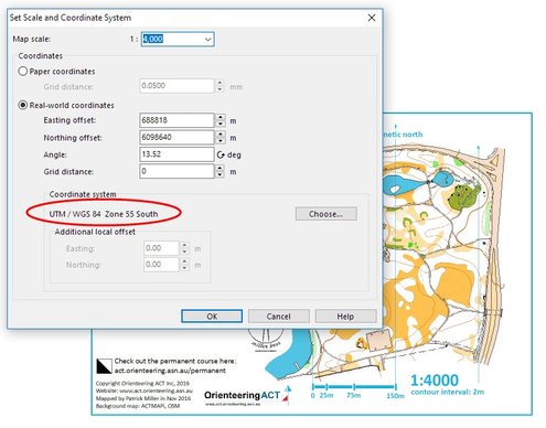
Ensure that your map is geo-referenced and has the coordinate system set as shown this screen print:
MyOMaps needs the coordinate system to be set to UTM/WGS84. Select the applicable Zone and Hemisphere relating to the location of your map.
Export your OCAD map (not the course file, but the underlying map file) as a KMZ file.
You will need Version 10 or later of OCAD to support geo-referenced OCAD maps.
Ensure that your map is geo-referenced and has the coordinate system set as shown this screen print:
MyOMaps needs the coordinate system to be set to UTM/WGS84. Select the applicable Zone and Hemisphere relating to the location of your map.
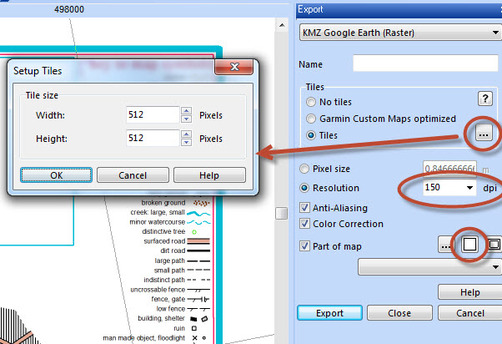
To export the Map as a KMZ file:
- Select >File > Export….
- A panel should appear on the right-hand-side (See screen print)
- Select KMZ from the pull-down list at the top of the panel
- Select Tiles – and enter 512 x 512
- Select a resolution eg 150dpi (recommended) (300dpi may be OK too, but it makes the KMZ much bigger)
- It is best to keep the size of KMZ files to be of the order of 1MB. You may need to reduce the dpi to achieve this.
- A 1:10000 orienteering map on A3 produced at 200dpi is within this range
- Select “Part of Map” – then select the middle button “Entire Map”
- Then press Export.
- It is best to use the same base name for the KMZ file as the file name of your OCAD file so that you can remember which version of the OCAD file was used to produce the KMZ. It is also useful to append to the name, the dpi resolution of this file. Eg If a 150dpi KMZ is produced from an OCAD file with the name "Taringa 2015v2.ocd", the recommended name for the KMZ file is "Taringa 2015v2 150.kmz".
- The following YouTube video demonstrates this process:
Export a Course from OCAD
Some features of MyOMaps (eg Score Events) rely upon there being only a single course in the course file and the course being named: "Course1". Also the Start should be named "S1" and the finish "F1".
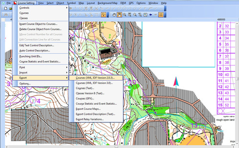
To export your course use (OCAD 11 example) >Course Setting > Export > Courses(XML IOF Version 2.0.3) as shown below:
Currently V3 of IOF XML is NOT supported.
This creates an XML file that contains details of the course and the location of each of the controls (in both x,y mm on the map page, and easting and northing in WGS84).
Some features of MyOMaps (eg Score Events) rely upon there being only a single course in the course file and the course being named: "Course1". Also the Start should be named "S1" and the finish "F1".
To export your course use (OCAD 11 example) >Course Setting > Export > Courses(XML IOF Version 2.0.3) as shown below:
Currently V3 of IOF XML is NOT supported.
This creates an XML file that contains details of the course and the location of each of the controls (in both x,y mm on the map page, and easting and northing in WGS84).
Other Systems - Purple Pen, Corpse, Condes
Courses can be prepared in other systems such as Corpse/Purple Pen/Condes etc, but as these systems are generally not geo-reference-aware. They produce IOF XML files where the controls are located by x,y positioning on the map sheet
This can lead to some inaccuracies, and the position of controls should be checked.
If you use these non-geo-referenced systems, care must be taken to use a map that is the same boundaries, rotation and top-left corner as the Map used to create the KMZ file, otherwise the x,y coordinates in the course file will not be correct for the KMZ file.
Using your Map and Course in MyOMaps
If you just want to use your map and course file yourself, you can copy the files to your device from your PC, or put the files on an SD Card and insert it into your phone, or you can email the files to your device. You will need the full version of MyOMaps for Android (Paid version from the Play Store) for this. In this version, you can change the location from which the files are retrieved. (Menu > Settings > Map and Course File Location)
Alternatively, an administrator can publish your event on the MyOMaps server. The event can be PIN protected for confidentiality.
Quick Checklist for MyOMaps Maps and Courses:
Use the following as a quick check before finalising your files:
Map:
- Map is geo-referenced and uses UTM/WGS84 coordinates
- KMZ file is tiled in 512x512 tiles
- KMZ file size is of the order of 1MB
Course File (XML) (See the Google Map page for the KML alternative)
- Format is IOF XML 2.0.3
- There is only one course in the file, with the name "Course1"
- The start is named "S1" and the finish "F1"
